Bastion 14 of London’s former City Wall stands as a ruined structure to the east of the Museum of London and is visible from the Museum’s Roman Gallery. Due to essential restoration works on its structure, Museum of London Archaeology has undertaken a standing building survey of the bastion.
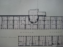
The medieval masonry structure lies on top of Roman foundations, whilst bricks were added, some relating to late-medieval repairs. However most of the brickwork relates to later buildings as the City Wall fell out of use and the bastion became increasingly hidden as a consequence of the development of the area around it. By the 19th century, the structure was entirely incorporated into the surrounding buildings as the City Surveyors plan from 1841 shows.
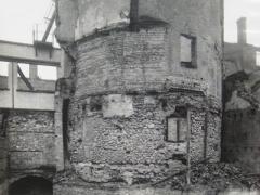

The area around Bastion 14 today has changed dramatically since the 19th century. During the Second World War, the area was entirely flattened by bombing and the four-storey buildings encasing the bastion were destroyed, revealing the medieval masonry structure and the rounded shape of the bastion, echoed in the brickwork of the later buildings. Before the war, the medieval masonry would have been visible at basement level of the buildings around it, as it still is today in a few other areas of the City.
The MOLA Geomatics team and Standing Building Recording team worked together during the standing building survey, using both hi-tech and manual recording techniques in order to produce a detailed record of the structure. 3-D laser-scan data, produced by Plowman Craven and processed by the Geomatics team, was used to create a 2-dimensional elevation with detail of every single stone. The gaps left on the elevation caused by obstructions such as foliage were hand-drawn by members of the Standing Building team, whilst on site analysis and annotated sketches of the different materials and construction phases were made. The result was a detailed elevation of the internal and external faces of the bastion showing the different types of building materials and the existing features.
The survey is currently being followed by the historical study and interpretation of the structure, with information gained from the local historical archives and on-line sources. The interpretation, based on the comparison between the archival information and the observation of the fabric, will lead to the reconstruction of the history of the remains of the bastion and identification of a sequence of development phases. Remnants and scars of the earlier abutting structures are evident on the elevation and provide much information about the past of the structure and the buildings that surrounded it.

