We’re delighted to announce the launch of our Coasts in Mind project ’s brand-new Mapping Platform!
The mapping platform is part of Coasts in Mind's pioneering community-led approach to addressing the impacts of climate change on coastal areas, co-created with local communities from the Taw-Torridge Estuary in Devon, Swale Estuary in North Kent, Poole Harbour in Dorset, and Sefton Coast in Merseyside. Made possible with support from The National Lottery Heritage Fund, the platform showcases how local knowledge can influence UK policymakers and researchers.
While the archaeological or scientific importance of at-risk coastal sites are recognised by specialists, the voices of locals are often not heard. However, through workshops and other activities, the Coasts in Mind team are tapping into this hidden pool of knowledge to amplify the experiences of people living along some of England’s most vulnerable stretches of coastline.
Co-designed with community members, the Coasts in Mind Mapping Platform is an exciting and unique new tool, that enables people to curate their own local evidence of climate and coastal change. In doing so, it will give greater value to the expertise of local knowledge and help empower communities to present their own narratives of change in a publicly accessible format.
Ultimately, we intend this to influence policymakers and wider public perceptions of change, including its causes and effects on local environments, heritage, and front-line communities. For this reason, we are focusing our map on four key regions over the next two years: Poole Harbour in East Dorset, Sefton Coast in Merseyside, Swale Estuary in North Kent and Taw-Torridge Estuary in North Devon.
The Coasts in Mind team are working with policymakers, researchers, and community groups involved in climate conversations to ensure this local record will become part of the debate. The map is also an exciting new source of information for anyone interested in the heritage, archaeology, and natural habitats of our changing coastlines.
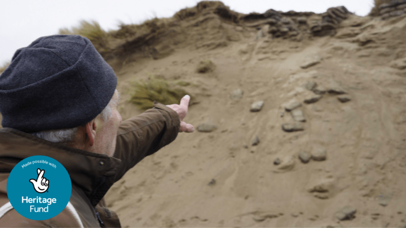
Among the at-risk coastal heritage already added to the map, which has been specially designed with HUMAP (the Digital Humanities Map Platform) and DigVentures are rapidly eroding Second World War dugouts at Northam Burrows on the north coast of Devon. Built to help protect Britain against invasion, the location of these previously hidden features is being revealed as a series of sandbag walls collapse onto the beach.
However, worsening winter storms are impacting this delicate dune system along with the archaeological features it contains, as Coasts in Mind Senior Community Archaeologist for the Taw-Torridge Estuary Kate Shear explains:
These dunes have historically been protected by the famous pebble ridge, which was rebuilt every year as part of a custom known as potwalloping. Potwallopers were members of the community who earned the right to graze their animals here in exchange for the work, and it became a local celebration. But now this iconic feature is shrinking. Over the next 25 years the pebble ridge is in danger of losing 150 metres of stones to erosion, allowing rising sea-levels to flood the Northam Burrows
As well as gathering evidence of how important local places, like the Northam Burrows, have changed over the past century, Coasts in Mind is bringing communities together to build resilience against the almost inevitable coastal changes they will experience.
Through a programme of free workshops, creative projects, and training opportunities over the next 6 months, Coasts in Mind is bringing communities together in its four key regions to build resilience against future coastal change. Participants can learn to add and moderate contributions to the map, before it is then opened for submissions from the wider community in May 2026.
It’s fantastic to see the Coast in Mind’s mapping tool launch, sharing people’s stories and memories of their coastal communities. It is a powerful example of how important it is to document these lived experiences to increase everyone’s understanding of coastal change. By capturing these stories, we’re not only preserving this heritage but also helping communities build resilience for the future
The Coasts in Mind project will stretch over 3-years, specifically targeting four key coastal regions – Poole Harbour in Dorset, Taw-Torridge Estuary in Devon, Swale Estuary in Kent, and Sefton Coast in Merseyside. The aim is for these initial pilot locations to be a model for how this innovative methodology can be used on a national scale, adding a vital piece of the puzzle to addressing the impacts of this globally significant issue.
This 3-year project is a model for how the Coasts in Mind methodology can be used on a national scale, adding a vital piece of the puzzle to addressing the impacts of this globally significant issue.
Explore the Coasts in Mind Mapping Platform at cim.mola.org.uk/map
