Archaeological research is not just about digging. Our work with the Cambridge Archaeological Unit on the National Highways A428 Black Cat to Caxton Gibbet Improvement Scheme has involved many different techniques. Up to now, we have been trying to understand how people lived at Field 44 by studying the objects and structures they left behind. Now it’s time to look at the site under the microscope, as we turn our focus to biological remains.
Human activities shape – and are in turn influenced – by the environment. Landscapes are constantly changing and what we see now is often quite different from what it was like thousands of years ago. Field 44 is no exception, and our teams have been busy trying to reconstruct the environment in which people lived and worked. This requires analysing ancient remains that are often very small, sometimes even invisible to the naked eye. However, the insights they gift us are invaluable.
Looking for clues
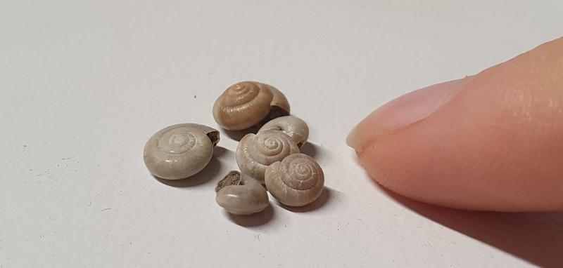
Plant seeds, pollen and insects are some of the many things we can look at when reconstructing past landscapes. However, these tiny organic remains don’t always survive the passage of time and are often only preserved when burned or discovered in a particularly wet environment. Sturdier objects – like snail shells and animal bones – tend to survive better.
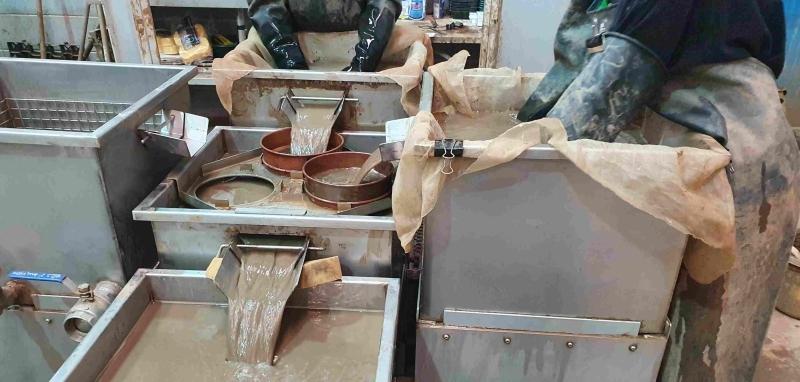
Our archaeologists have been collecting soil samples from Field 44, all carefully chosen to make sure they capture the most important surviving biological remains. These samples are carefully processed using a technique known as flotation. This uses water and sieves to separate the soil from the materials we are interested in, such as charred plant seeds, snail shells and small animal bones. Now the analysis can start!
To beer or not to beer
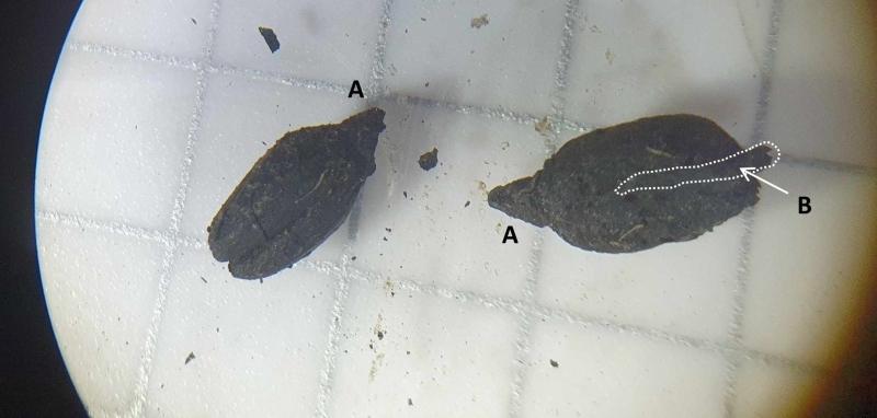
Plant seeds have interesting stories to tell, especially cereals. We have found charred spelt grains by what was initially identified as a Roman ‘corn dryer’, a structure similar to an oven used to slowly dry grain before they can be stored or ground into flour. However, these grains were ‘germinated’, meaning they had started to put out shoots.
Why is this detail so important? Because grains are allowed to germinate in quantity before being dried only when people are making malt, the first step to produce beer.
These charred, germinated grains were accidentally burned during the drying process. Surprisingly, we haven’t found clear evidence of the structures needed for brewing, so we still don’t know if the people living at Field 44 were also making beer on site. They might have simply produced the malt, which was then brewed somewhere else. This raises interesting questions about whether the settlement was part of a wider trade network, its inhabitants well-connected with their neighbours in the region and beyond.
Were the people here drinking their own beer or trading in malt? Or maybe they did both?! As our work continues across other A428 sites, this is a question we hope to answer!
What did the land around Field 44 look like?
The study of plant and animal remains is not just shedding light on what people ate and drank at Field 44. It is also helping us picture what the surrounding landscape would have looked like in the past. Currently, we think the settlement had an open, grassy habitat. This would have included areas of slightly damp meadow and patches of rough ground, with plants such as nettles and docks.
How do we know all of this? Snail shells, waterlogged plants and insects play an important role. Our environmental archaeologists have already identified some of these plants (grasses, silverweed, buttercups, rushes), as well as snail species usually found in these types of environments.
But this is not all. Our experts have also identified a particular kind of plant called ‘henbane’, usually found in soils that are particularly warm and rich in nitrogen. What are we talking about? Well, most likely, manure or rubbish. Henbane was identified in a sample collected from a large Late Iron Age watering-hole (c.100 BC-AD 43), just by the eastern boundary of the settlement. As we analyse more samples, we will see if the plant was only present at a specific time or place at the farmstead. This will show us some of the places where waste gathered, possibly telling us where livestock was kept.
Next Steps: going beyond Field 44
Research continues, and we still have questions to answer. For example, what did the environment in the region look like? We can find out using the pollen spread by ancient trees and grasses. Wind-blown pollen can travel long distances, which is why it can help us reconstruct the wider landscape around the site.
Luckily, at Field 44 there is excellent potential for pollen analysis! The eastern part of the settlement includes a shallow valley where groundwater naturally gathers. This is called a ‘dry valley’, even thought it was actually very wet. During the Iron Age and Roman periods, this valley contained deep ditches and watering holes. Over time, these were filled with soil and waste packed with organic remains, which due to the boggy, oxygen-poor conditions are incredibly well-preserved. Vertical blocks of this pollen-rich wet soil have been cut from the ground at carefully selected places, creating what the experts call ‘pollen tin sequences’. These will be analysed in a laboratory to extract, identify and date the pollen.
JOIN US ON OUR JOURNEY!
- @A428Cat
- Facebook.com/A428BlackCat
- #A428BlackCat
- Find out more about the A428 National Highways scheme
Excavations at Field 44 are being undertaken by archaeologists from MOLA and Cambridge Archaeological Unit, as part of the proposed National Highways A428 Black Cat to Caxton Gibbet Improvement Scheme managed by Skanska.


